
The fire in the Mallee region of South Australia occurred on the 20th January 2018. The fire, which was started by lightning strikes the day before, burnt through native vegetation near the Karte Conservation Park and within the Peebinga Conservation Park. The FireFlight system was used to image the fire at a height of 9000 feet above ground level, at approx 1600 local time on the 20th. At the time of the flyover, crews had completed back burns to the north eastern boundary, and to the southern boundary, establishing control lines.
The image below is a composite of six flight runs that were flown over the fire over a period of 20 minutes. During this time the fire moved a small distance to the north and west.
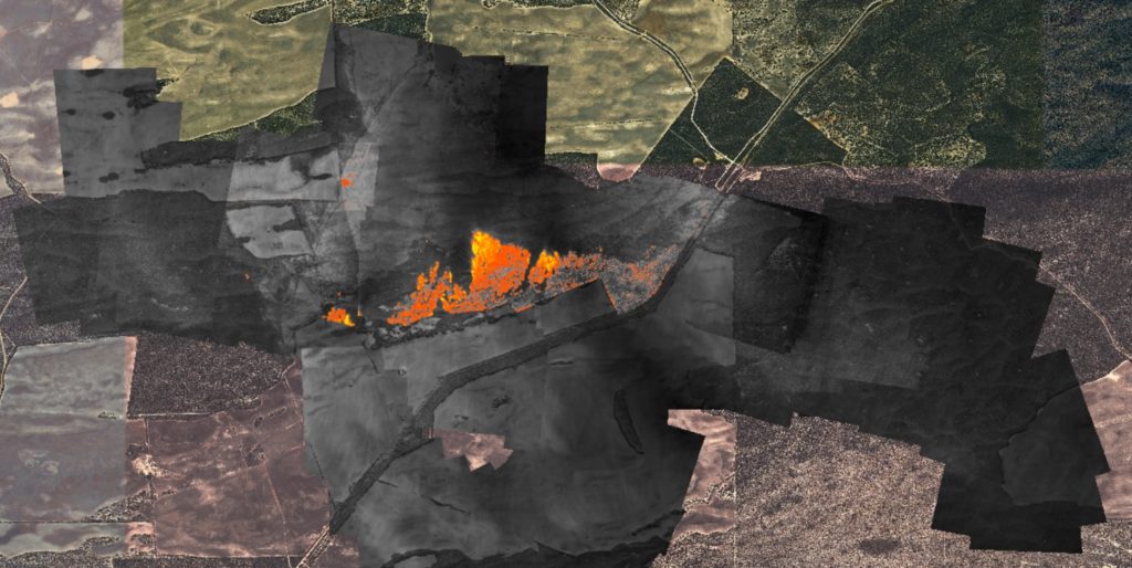
Key to the above image:
- Coloured background from Google Earth
- Grey/black areas are those areas where thermal imagery was acquired
- Orange is any ground that is at least 50 degrees centrigrade
- Yellow is any ground that is 200 degrees centigrade or above
The individual passes flown across the fire can be viewed in high resolution, and overlaid on to Google Maps, using the links below:
- Pass 1 at 1551 ACDT
- Pass 2 at 1556 ACDT
- Pass 3 at 1601 ACDT
- Pass 4 at 1606 ACDT
- Pass 5 at 1610 ACDT
- Pass 6 at 1612 ACDT
About the FireFlight aerial fire mapping system
The FireFlight aerial fire mapping system has been developed by Spatial Scientific Pty. Ltd., an Adelaide (Australia) based spatial technology company. Important features of the FireFlight system include:
- A combination of thermal imaging cameras with high precision GPS and advanced data processing software.
- Specifically designed for use on manned aircraft and helicopters (we do not use drones at this stage, and we do not fly drones near fires).
- An ability to map fires in and deliver data (such as that shown above) in real time. Data is available within one minute of being acquired.
- The FireFlight system is cost-effective: it can be deployed on multiple aircraft, each positioned in high fire danger zones.
- Although developed in Australia, the FireFlight system can be deployed worldwide.
Please contact us for further information. An information sheet describing the FireFlight system is available here.